- Client
- Internal Research Project
- Collaborator
- Stamen
We’re always looking for tools to help us see cities from a new perspective. Sometimes we build our own.
Concurrent with a larger project imagining ways that civic assets could be repositioned as more central to the lives of everyday Philadelphians, we found ourselves wondering what people think of post offices, parks, and the like. Usually the best way to determine attitudes about a place is to get out there and talk to people, but in this project we were interested in using technology to help us achieve more scale.
The website Yelp.com is popular for collecting ratings and reviews of restaurants and shops, but it also collects the same data on civic assets. We used this as a freely available data source to explore ways to visualize the sentiment of a city. Let us say this up front: Yelp data is by no means a representative sample for an entire city. This was not intended as a definitive tool. It was created to test how quickly we could develop a high-level snapshot using pre-existing, publicly available data.

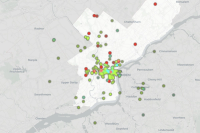
Our experimentation in this project builds on discoveries during our prior work on A Possible Philadelphia and Librariness. We found that residents of a city scarcely see civic assets as an isolated category. Instead, civic institutions, such as libraries, find themselves in unlikely competition with commercial options, such as bookstores and Amazon. This mapping tool, conceptualized by Dash and built by our friends at Stamen, helps us understand the public perception of assets, which is a useful insight when considering where and how to begin imagining a new future for these assets.
In addition to providing an overview ‘heatmap’ of the city, the mapping tools allows you to isolate specific asset types. Doing so reveals systems that are highly appreciated, like parks; those that are universally unappreciated, such as the post office; and those with a bit of both, such as mobility infrastructure.
- Code: Stamen